


 (1)
(1)
Kategorien

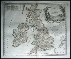
Postroutenkarte von Großbritannien und Irland, "Carte des ...mehr
Postroutenkarte von Großbritannien und Irland, "Carte des Grandes
Routes"
![Auktion]](/de/images/philasearch/ico_people.png "Auktion")
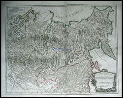
der östliche Teil von Rußland, "Partie Orientale de L`Empire ...mehr
der östliche Teil von Rußland, "Partie Orientale de L`Empire de
Russie
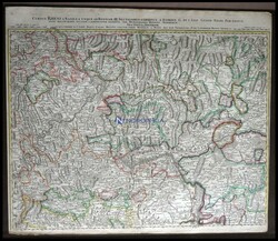
Rheinverlauf (Unterrheingegend) bei Köln und der ...mehr
Rheinverlauf (Unterrheingegend) bei Köln und der Moselgegend,
"Cursus Rheni auf Basilea usque ad Bonnam (sectio seu Inferior),
altkolorierter Kupferstich von Homann ca. 1750
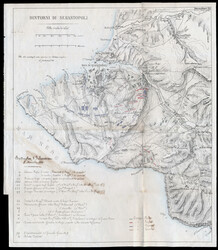
Sardegna. Guerra di Crimea, Mappa dettagliata (32cm x 37cm) ...mehr
Sardegna. Guerra di Crimea, Mappa dettagliata (32cm x 37cm) della
Battaglia di Inkerman del 5 Novembre 1854. Tracce di sbavature ma
nel complesso chiara e ben tenuta

Miscellaneous. Map. 1931-65 four old maps; 1. 1930s map of Gai
Ping ...mehr Miscellaneous. Map. 1931-65 four old maps; 1. 1930s map of Gai Ping
Xian, 2.1930s map of Hamgyeong-Go North Korea, 3.1938 map of
Xinjing and 4. map of Vietnam anti-US. (Estimate 300 US$ - 500 US$)
Automatisch generierte Übersetzung:
Verschiedenes. Landkarte. 1931-65 vier alte Stadtpläne; 1. 1930er-Jahre Landkarte von Gai Ping Xian, 2. 1930er-Jahre Landkarte von Hamgyeong-Go Nordkorea, 3. 1938 Landkarte von Xinjing und 4. Landkarte von Vietnams anti-US. (Schätzpreis 300 US$ - 500 US$)
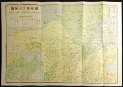
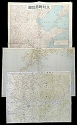
Miscellaneous. Map. 1937 Map of North - China, by Shanghai
Geology ...mehr Miscellaneous. Map. 1937 Map of North - China, by Shanghai Geology
Learning Society, with original cove. size: 54 x 76cm (Estimate 400
US$ - 600 US$)
Automatisch generierte Übersetzung:
Verschiedenes. Landkarte. 1937 Landkarte von Nord - China, bei Shanghai Geologie Bildung Societät, mit ursprünglichem cove. Größe: 54 x 76cm (Schätzpreis 400 US$ - 600 US$)
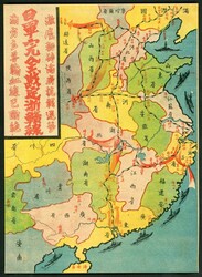
Miscellaneous. Map. 1937-1946 A color map of the strategic
situation ...mehr Miscellaneous. Map. 1937-1946 A color map of the strategic
situation printed during the Japanese invasion of China. It
describes the Japanese army's deployment to cut off the lifeline of
Chungking (Yufu), the temporary capital in war time. The back of
the book talks about the Japanese army's military achievements in
Chinese. It is a rare propaganda product from the Japanese army
during the Anti-Japanese War. Size: 19 x 26.2cm (Estimate 400 US$ -
800 US$)
Automatisch generierte Übersetzung:
Verschiedenes. Landkarte. 1937-1946 ein Farbe Landkarte von die kriegswichtig Situation gedruckt während die japanische Einmarsch von China. Es beschreibt die japanische armys Aufmarschieren in Linie abnehmen die Rettungsleine von Chungking (Yufu), die vorübergehend Hauptstadt in Kriegszeit. Die extra katalogisierte Ausgaben spricht über die japanische armys Militär Leistungen in Chinesisch. Es ist eine seltene Propaganda Gebilde ab die japanische Armeen während der japanfeindlich War. Größe: 19 x 26. 2cm (Schätzpreis 400 US$ - 800 US$)
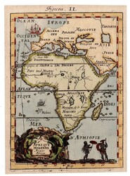
Various MAPS Mozambique. Maillet's 17th-century map of Africa, dated ...mehr
Various MAPS Mozambique. Maillet's 17th-century map of Africa, dated 1684, colored
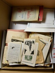
VARIA: Todesanzeigen, Gebetsbildchen, Landkarten, Zeitschriften usw., ...mehr
VARIA: Todesanzeigen, Gebetsbildchen, Landkarten, Zeitschriften usw., großartiges Los
Original niederländische Beschreibung:
VARIA: Doodsprentjes, bidprentjes, landkaarten, tijdschriften, enz., formidabel lot
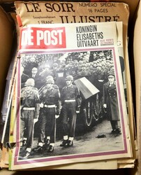
VARIA: Zeitschrift „Moederhart“ usw. + „La mode illustré“ + ...mehr
VARIA: Zeitschrift „Moederhart“ usw. + „La mode illustré“ + Fotos (Leopold II. und Albert I.), Landkarten, Reproduktionen, Zeitschrift „Vlaamsche illustratie“ 1897 usw.
Original niederländische Beschreibung:
VARIA: Tijdschrift "Moederhart", enz. + "La mode illustré" + foto's (Leopold II en Albert I), landkaarten, reproducties, tijdschrift Vlaamsche illustratie 1897, enz.

CARTE GEOGRAFICHE - Lotto di otto carte geografiche ...mehr
CARTE GEOGRAFICHE - Lotto di otto carte geografiche dell'I.G.M.
telate edizione anni '30 con i territori di Albenga-Savona,
Altare,Ceva, Sanremo. Pigna, Triora, Taggia e Susa, inoltre tre
carte del Touring Club Ciclistico Italiano con planimetrie e
profili ciclistici Cosenza-Castrovillari, Passo della Maloja e
Aquila-Popoli, una carta Fratelli Bertola Editori territorio di
Carmagnola 1907 (telata) più un atlante scolastico e svariate carte
di varie epoche, notate due carte ad uso delle truppe tedesche
(Pinerolo e Sommariva Bosco); insieme interessante
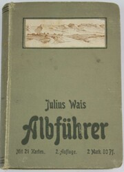
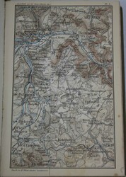
"Albführer" Wanderung durch die Schwäbische Alb nebst Hegau ...mehr
"Albführer" Wanderung durch die Schwäbische Alb nebst Hegau und
Randen von Julius Wais. Mit 21 Karten meist vierfarbige Karten.
Zweite, neu bearbeitete Auflage.
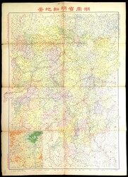
Miscellaneous. Map. 1947 Hunan Province Detailed Map in clour,
by ...mehr Miscellaneous. Map. 1947 Hunan Province Detailed Map in clour, by
Wuchang Yaxin Geology Learning Society. Size: 55 x 78cm (Estimate
300 US$ - 500 US$)
Automatisch generierte Übersetzung:
Verschiedenes. Landkarte. 1947 Hunan Provinz ausführliche Landkarte in clour, bei Wuchang Yaxin Geologie Bildung Societät. Größe: 55 x 78cm (Schätzpreis 300 US$ - 500 US$)
Miscellaneous. Map. 1970s a printed version of the "Hong Kong
Street ...mehr Miscellaneous. Map. 1970s a printed version of the "Hong Kong
Street District Map" has been framed for nostalgic display. Frame
size: 39 x 46.7cm (Estimate 800 US$ - 1000 US$)
Automatisch generierte Übersetzung:
Verschiedenes. Landkarte. 1970er-Jahren ein gedruckt Ausgabe des "Hongkong Strasse Stadtteilkarte" wurde eingerahmt für nostalgisch anzeigen. Rahmengröße: 39 x 46. 7cm (Schätzpreis 800 US$ - 1000 US$)
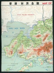
Miscellaneous. Map. 1970s map of Hong Kong and the New
Territories, ...mehr Miscellaneous. Map. 1970s map of Hong Kong and the New Territories,
with a tourist map of Hong Kong attractions on the back, published
by Art & Beauty Books. Good condition. Size 7/18/2025 39 x 53cm
(Estimate 300 US$ - 500 US$)
Automatisch generierte Übersetzung:
Verschiedenes. Landkarte. 1970er-Jahren Landkarte von Hongkong und die neu Gebiete, mit ein touristische Landkarte von Hongkong Attraktionen rückseitig, herausgegeben von Kunst und Schönheit Bücher. Gute Erhaltung. Größe 7/18/2025 39 x 53cm (Schätzpreis 300 US$ - 500 US$)
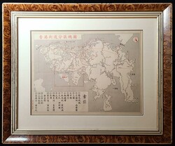
Miscellaneous. Others. 1910's Map of Harbin, Port Arthur and
North ...mehr Miscellaneous. Others. 1910's Map of Harbin, Port Arthur and North
China, good condition. (Estimate 300 US$ - 400 US$)
Automatisch generierte Übersetzung:
Verschiedenes. Andere. 1910s Landkarte von Harbin, Port Arthur und Nordchina, gute Erhaltung. (Schätzpreis 300 US$ - 400 US$)
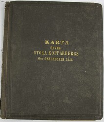
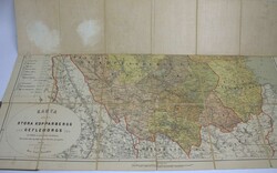
schwedischer Atlas "Karta Öfver Stora Kopparbergs Och ...mehr
schwedischer Atlas "Karta Öfver Stora Kopparbergs Och Gefleborgs
Län" Karte der schwedischen Provinzen Stora Kopparberg (heute
Dalarna) und Gävleborg. Gebrauchter Zustand.
Old archive from the 1910s to the 1940s! Maps and other interesting ...mehr
Old archive from the 1910s to the 1940s! Maps and other interesting guides from H. Gröndahl, who served as Finnish maritime agent in London 1935 - 1941 and in Washington in 1943, from various countries including England, France, USA, Germany, Sweden, Russia etc
Konvolut historischer Postkarten, Landkarten und Feldpost
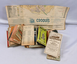
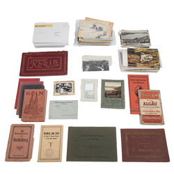
Deutschland ...mehr Konvolut historischer Postkarten, Landkarten und Feldpost Deutschland - aus der ersten Hälfte des 20. Jhds., deutsche Städte u.a. Blaubeuren, Heidenheim, Heidelberg, 3 x Landkarten u.a. Mainz-Köln, 3 x Ansichtsbücher mit Stichen, 7 x Postkartenbücher, 36 x Feldpost aus dem 1.WK, und ca. 350 x Postkarten, überwiegend unbeschrieben, wiederkehrender Name 'Karl Burger'. Mit Alters- und Gebrauchsspuren, Verfärbungen, Stockflecken. Bitte besichtigen!
Miscellaneous. Map. 1949 reprint of a map of Hong Kong's
"Lantau ...mehr Miscellaneous. Map. 1949 reprint of a map of Hong Kong's "Lantau
Island" (Tai Ho Island). The original map was produced in 1927 by
the Northeast Military Command of the Chinese People's Liberation
Army. Size: 42 x 54cm (Estimate 300 US$ - 400 US$)
Automatisch generierte Übersetzung:
Verschiedenes. Landkarte. 1949 Neudruck einer Landkarte von Hong Kongs "Lantau Insel" (Tai Ho Insel). Die original Landkarte wurde hergestellt in 1927 von dem Nordosten Militärkommando des chinesischer Volksbefreiungsarmee. Größe: 42 x 54cm (Schätzpreis 300 US$ - 400 US$)
Nordphila e.K.
Los 4271
Mi
(46x56)
100.00 EUR
09.11.2025 12:00 CET
Nordphila e.K.
Los 4279
Mi
(46x57)
100.00 EUR
09.11.2025 12:00 CET
Nordphila e.K.
Los 4270
Mi
(46x57)
210.00 EUR
09.11.2025 12:00 CET
Cedarstamps Auction House
Los 40
100.00 EUR
13.09.2025 14:00 EEST
Spink China
Los 1461
Ping ...mehr Miscellaneous. Map. 1931-65 four old maps; 1. 1930s map of Gai Ping
Xian, 2.1930s map of Hamgyeong-Go North Korea, 3.1938 map of
Xinjing and 4. map of Vietnam anti-US. (Estimate 300 US$ - 500 US$)
Automatisch generierte Übersetzung:
Verschiedenes. Landkarte. 1931-65 vier alte Stadtpläne; 1. 1930er-Jahre Landkarte von Gai Ping Xian, 2. 1930er-Jahre Landkarte von Hamgyeong-Go Nordkorea, 3. 1938 Landkarte von Xinjing und 4. Landkarte von Vietnams anti-US. (Schätzpreis 300 US$ - 500 US$)
300.00 HKD
(ca. 33 EUR)
31.10.2025 14:00 HKT
(ca. 33 EUR)
Spink China
Los 1462
Geology ...mehr Miscellaneous. Map. 1937 Map of North - China, by Shanghai Geology
Learning Society, with original cove. size: 54 x 76cm (Estimate 400
US$ - 600 US$)
Automatisch generierte Übersetzung:
Verschiedenes. Landkarte. 1937 Landkarte von Nord - China, bei Shanghai Geologie Bildung Societät, mit ursprünglichem cove. Größe: 54 x 76cm (Schätzpreis 400 US$ - 600 US$)
400.00 HKD
(ca. 44 EUR)
31.10.2025 14:00 HKT
(ca. 44 EUR)
Spink China
Los 1463
situation ...mehr Miscellaneous. Map. 1937-1946 A color map of the strategic
situation printed during the Japanese invasion of China. It
describes the Japanese army's deployment to cut off the lifeline of
Chungking (Yufu), the temporary capital in war time. The back of
the book talks about the Japanese army's military achievements in
Chinese. It is a rare propaganda product from the Japanese army
during the Anti-Japanese War. Size: 19 x 26.2cm (Estimate 400 US$ -
800 US$)
Automatisch generierte Übersetzung:
Verschiedenes. Landkarte. 1937-1946 ein Farbe Landkarte von die kriegswichtig Situation gedruckt während die japanische Einmarsch von China. Es beschreibt die japanische armys Aufmarschieren in Linie abnehmen die Rettungsleine von Chungking (Yufu), die vorübergehend Hauptstadt in Kriegszeit. Die extra katalogisierte Ausgaben spricht über die japanische armys Militär Leistungen in Chinesisch. Es ist eine seltene Propaganda Gebilde ab die japanische Armeen während der japanfeindlich War. Größe: 19 x 26. 2cm (Schätzpreis 400 US$ - 800 US$)
400.00 HKD
(ca. 44 EUR)
31.10.2025 14:00 HKT
(ca. 44 EUR)
Frazao Auctions
Los 2356
100.00 EUR
03.11.2025 16:00 WET
Van Looy Briefmarkenauktionen
Los 350
Original niederländische Beschreibung:
VARIA: Doodsprentjes, bidprentjes, landkaarten, tijdschriften, enz., formidabel lot
LIVE!
195.00 EUR
Verkauft
Van Looy Briefmarkenauktionen
Los 352
1 weitere Abbildung
Original niederländische Beschreibung:
VARIA: Tijdschrift "Moederhart", enz. + "La mode illustré" + foto's (Leopold II en Albert I), landkaarten, reproducties, tijdschrift Vlaamsche illustratie 1897, enz.
LIVE!
40.00 EUR
Verkauft
Filatelia Gazzera
Los 1063
70.00 EUR
30.09.2025 13:00 CEST
Leininger Auktionshaus
Los 1032
LIVE!
10.00 EUR
Verkauft
Spink China
Los 1464
by ...mehr Miscellaneous. Map. 1947 Hunan Province Detailed Map in clour, by
Wuchang Yaxin Geology Learning Society. Size: 55 x 78cm (Estimate
300 US$ - 500 US$)
Automatisch generierte Übersetzung:
Verschiedenes. Landkarte. 1947 Hunan Provinz ausführliche Landkarte in clour, bei Wuchang Yaxin Geologie Bildung Societät. Größe: 55 x 78cm (Schätzpreis 300 US$ - 500 US$)
300.00 HKD
(ca. 33 EUR)
31.10.2025 14:00 HKT
(ca. 33 EUR)
Spink China
Los 1466
Street ...mehr Miscellaneous. Map. 1970s a printed version of the "Hong Kong
Street District Map" has been framed for nostalgic display. Frame
size: 39 x 46.7cm (Estimate 800 US$ - 1000 US$)
Automatisch generierte Übersetzung:
Verschiedenes. Landkarte. 1970er-Jahren ein gedruckt Ausgabe des "Hongkong Strasse Stadtteilkarte" wurde eingerahmt für nostalgisch anzeigen. Rahmengröße: 39 x 46. 7cm (Schätzpreis 800 US$ - 1000 US$)
800.00 HKD
(ca. 88 EUR)
31.10.2025 14:00 HKT
(ca. 88 EUR)
Spink China
Los 1467
Territories, ...mehr Miscellaneous. Map. 1970s map of Hong Kong and the New Territories,
with a tourist map of Hong Kong attractions on the back, published
by Art & Beauty Books. Good condition. Size 7/18/2025 39 x 53cm
(Estimate 300 US$ - 500 US$)
Automatisch generierte Übersetzung:
Verschiedenes. Landkarte. 1970er-Jahren Landkarte von Hongkong und die neu Gebiete, mit ein touristische Landkarte von Hongkong Attraktionen rückseitig, herausgegeben von Kunst und Schönheit Bücher. Gute Erhaltung. Größe 7/18/2025 39 x 53cm (Schätzpreis 300 US$ - 500 US$)
300.00 HKD
(ca. 33 EUR)
31.10.2025 14:00 HKT
(ca. 33 EUR)
Spink China
Los 1475
North ...mehr Miscellaneous. Others. 1910's Map of Harbin, Port Arthur and North
China, good condition. (Estimate 300 US$ - 400 US$)
Automatisch generierte Übersetzung:
Verschiedenes. Andere. 1910s Landkarte von Harbin, Port Arthur und Nordchina, gute Erhaltung. (Schätzpreis 300 US$ - 400 US$)
300.00 HKD
(ca. 33 EUR)
31.10.2025 14:00 HKT
(ca. 33 EUR)
Leininger Auktionshaus
Los 1053
1 weitere Abbildung
LIVE!
5.00 EUR
Verkauft
Hellman Auktionen
Los 307
1 weitere Abbildung
30.00 EUR
06.10.2025 09:00 EEST
Eppli
Los 1
6 weitere Abbildungen
Deutschland ...mehr Konvolut historischer Postkarten, Landkarten und Feldpost Deutschland - aus der ersten Hälfte des 20. Jhds., deutsche Städte u.a. Blaubeuren, Heidenheim, Heidelberg, 3 x Landkarten u.a. Mainz-Köln, 3 x Ansichtsbücher mit Stichen, 7 x Postkartenbücher, 36 x Feldpost aus dem 1.WK, und ca. 350 x Postkarten, überwiegend unbeschrieben, wiederkehrender Name 'Karl Burger'. Mit Alters- und Gebrauchsspuren, Verfärbungen, Stockflecken. Bitte besichtigen!
LIVE!
200.00 EUR
Verkauft
Spink China
Los 1465
"Lantau ...mehr Miscellaneous. Map. 1949 reprint of a map of Hong Kong's "Lantau
Island" (Tai Ho Island). The original map was produced in 1927 by
the Northeast Military Command of the Chinese People's Liberation
Army. Size: 42 x 54cm (Estimate 300 US$ - 400 US$)
Automatisch generierte Übersetzung:
Verschiedenes. Landkarte. 1949 Neudruck einer Landkarte von Hong Kongs "Lantau Insel" (Tai Ho Insel). Die original Landkarte wurde hergestellt in 1927 von dem Nordosten Militärkommando des chinesischer Volksbefreiungsarmee. Größe: 42 x 54cm (Schätzpreis 300 US$ - 400 US$)
300.00 HKD
(ca. 33 EUR)
31.10.2025 14:00 HKT
(ca. 33 EUR)
Aktuelle Zeit: 22.10.2025 - 16:18 Uhr MET