


Categories

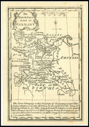
NORTH EAST part of Germany, copper engraving from the atlas MINIMUS, ...more
NORTH EAST part of Germany, copper engraving from the atlas MINIMUS, by J. Gibson, London 1774
![Auction]](/en/images/philasearch/ico_people.png "Auction")
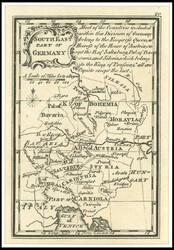
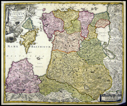
SOUTH EAST part of Germany, copper engraving from the atlas MINIMUS, ...more
SOUTH EAST part of Germany, copper engraving from the atlas MINIMUS, by J. Gibson, London 1774
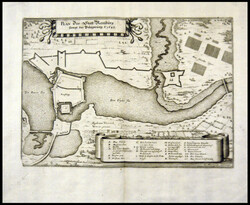
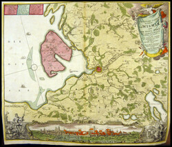
Plan of the city Rendsburg including the siege from 1645, copper ...more
Plan of the city Rendsburg including the siege from 1645, copper engraving by C. Maedefeldt from approximate 1650
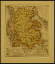
Duchy SCHLESWIG, original coloured lithography, 1871
Duchy SCHLESWIG, original coloured lithography, 1871
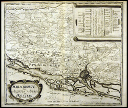
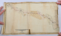
route the ALLIIRTEN army in HOLSTEIN, in the year 1700, original ...more
route the ALLIIRTEN army in HOLSTEIN, in the year 1700, original coloured copper engraving by Jonah Haas, 1743
DUCATUS HOLSTATIAE nova table, additional small cards from Deesbüll ...more
DUCATUS HOLSTATIAE nova table, additional small cards from Deesbüll and Stapelholm! original coloured copper engraving by Blaeu, 1640
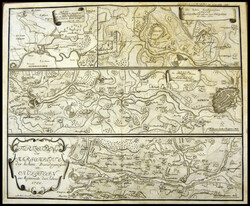
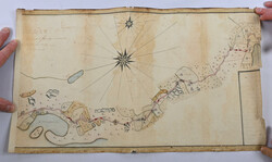
continuation of the marching route of the high allies in Holstein in ...more
continuation of the marching route of the high allies in Holstein in the month of May of the year 1700, 4 environmental plans with the respective ski jumps on one page: Segeberg with Ihlsee, Lauenburger corner, Luebeck and Dithmarschen, copper engraving by Jonah Haas about 1743
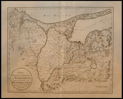
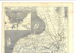
Gdansk, ELBING, and MARIENBURG or the first page from West Prussia, ...more
Gdansk, ELBING, and MARIENBURG or the first page from West Prussia, boundaries contemporary coloured copper engraving by Joh. FRID. Endersch, 1789
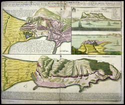
newest and exacter PLAN and PROSPECT from of the city VESTUNG, Bav ...more
newest and exacter PLAN and PROSPECT from of the city VESTUNG, Bav and FORTIEICATION from GIBRALTAR, reverse partly reinforces, original coloured copper engraving by Homann, approximate 1733
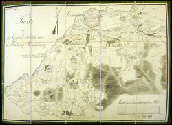
the area south of the fortress Rendsburg, Fold plan in the slipcase, ...more
the area south of the fortress Rendsburg, Fold plan in the slipcase, steel engraving 1833
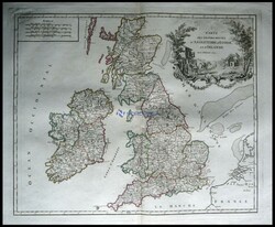
Postal route map from Great Britain and Ireland, Carte of the Grandes ...more
Postal route map from Great Britain and Ireland, Carte of the Grandes Routes
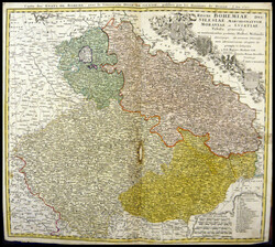
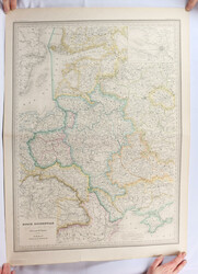
REGNI BOHEMIAE, DUC. SILESIAE, MARCHIONATUUM MORAVIAE et LUSATIAE ...more
REGNI BOHEMIAE, DUC. SILESIAE, MARCHIONATUUM MORAVIAE et LUSATIAE table generalis, slight traces of age, original coloured copper engraving by Homann, 1748
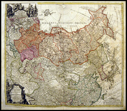
IMPERIL RUSSICI, original coloured copper engraving, 1739
IMPERIL RUSSICI, original coloured copper engraving, 1739
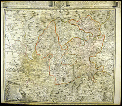
Repraesentatio geography a CIRCULI EGERANI nec none ELNBO, original ...more
Repraesentatio geography a CIRCULI EGERANI nec none ELNBO, original coloured copper engraving, 1748
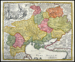
Black Sea Arena with Ukraine VKRANIA quae et earth COSACCORUM, ...more
Black Sea Arena with Ukraine VKRANIA quae et earth COSACCORUM, original coloured copper engraving by Homann, about 1740
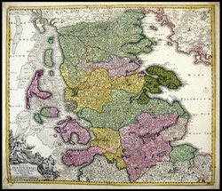
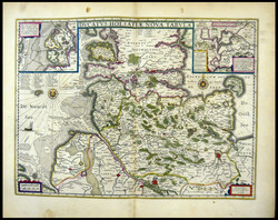
general map DUCATUS SLESVICENSIS, original coloured copper engraving ...more
general map DUCATUS SLESVICENSIS, original coloured copper engraving by Homann, about 1740
DUCATUUM LIUONIAE et CURLANDIAE, original coloured copper engraving ...more
DUCATUUM LIUONIAE et CURLANDIAE, original coloured copper engraving by Homann, 1720
Particulier Carte the area from WISMAR together with the island PÖEL ...more
Particulier Carte the area from WISMAR together with the island PÖEL and indicated Bloquade by water and Lande 1715, original coloured copper engraving by Homann, approximate 1718
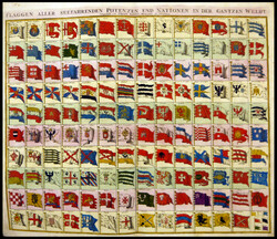
flags of all seafaring potencies and nations in the Gantzen world, ...more
flags of all seafaring potencies and nations in the Gantzen world, original coloured copper engraving by Homann, 1730
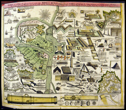
Chalkboard in which of all belonging work attester to the art of war ...more
Chalkboard in which of all belonging work attester to the art of war -Vestungsbau and artillery to the siege the cities, forts. to be needed, very decorative, original coloured copper engraving by Homann about 1749
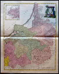
table REGNIBO RUSSIAE, BORUSSSLAM oriental exhibens, original ...more
table REGNIBO RUSSIAE, BORUSSSLAM oriental exhibens, original coloured copper engraving by Homann, 1775
Baltic states / Russia ca. 1860 size ca. 55 x 75 cm. Normal ...more
Baltic states / Russia ca. 1860 size ca. 55 x 75 cm. Normal patina
and a few peripheral tears
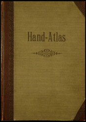
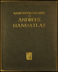
Andree, Richard: general Hand atlas in 86 cards, publishing house ...more
Andree, Richard: general Hand atlas in 86 cards, publishing house from Velhagen & Klasing, Bielefeld and Leipzig, 1881, cover rubbed, a little toned and stained, age-appropriate good condition
Andrees Hand atlas, supplement to the second and first issue, ...more
Andrees Hand atlas, supplement to the second and first issue, containing the 64 sides new cards the third edition from 1893, half calf, with leather corners, cover rubbed, cards browned, age-appropriate good condition
Richard Andrees: supplement to the first issue from Richard Andrees ...more
Richard Andrees: supplement to the first issue from Richard Andrees Hand atlas, containing the 33 sides new cards the second edition from 1887, Velhagen & Klasing, Bielefeld Leipzig, cover in half calf, a little stained, otherwise age-appropriate in good condition
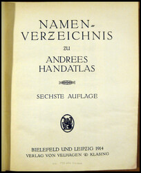
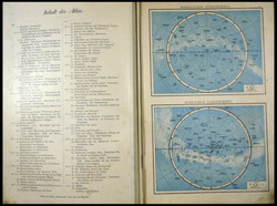
index of names to Andrees Hand atlas – sixth edition, publishing ...more
index of names to Andrees Hand atlas – sixth edition, publishing house Velhagen & Klasing, 1914, Bielefeld, Leipzig
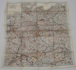
DR, Landkarte mit den Grenzen bis 1945, farbig auf Seide gedruckt, ...more
DR, Landkarte mit den Grenzen bis 1945, farbig auf Seide gedruckt,
ca. 50x50cm, für britische Flugzeugbesatzungen und Agenten, Maßstab
1:2 mio/31,5 engl. miles to 1 inch
Automatically generated translation:
DR, map with the confines to 1945, coloured on Silk printed, approximate 50 x50 cm, for British crews of and aircraft and agent, measurement 1: 2 million / 31, 5 English paint to 1 inch
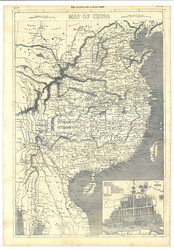
1858 (24 Jul) The Illustrated London News p.89-92. With a map of ...more
1858 (24 Jul) The Illustrated London News p.89-92. With a map of China. Please note tht it only includes China Proper. (size 54 x 80cm).
1858.7.24《The Illustrated London News》第89至92頁。印有中國地圖。54 x 80厘米。
Road map Hamina - Swedish border from 1776, age patina
Road map Hamina - Swedish border from 1776, age patina
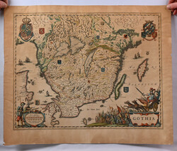
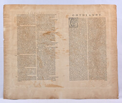
Gothia from ca. 1650, issued by Johan Blaeu. Size ca. 53 x 41 ...more
Gothia from ca. 1650, issued by Johan Blaeu. Size ca. 53 x 41 cm.
Typical age patina
Nordphila e.K.
Lot 4370
Mi
(7x10)
45.00 EUR
03/30/2026 16:00 CEST
Nordphila e.K.
Lot 4369
Mi
(7x10)
45.00 EUR
03/30/2026 16:00 CEST
Nordphila e.K.
Lot 4375
Mi
(22x32)
40.00 EUR
03/30/2026 16:00 CEST
Nordphila e.K.
Lot 4374
Mi
(25x21)
45.00 EUR
03/30/2026 16:00 CEST
Nordphila e.K.
Lot 4373
Mi
(37x43)
45.00 EUR
03/30/2026 16:00 CEST
Nordphila e.K.
Lot 4372
Mi
(38x51)
160.00 EUR
03/30/2026 16:00 CEST
Nordphila e.K.
Lot 4377
Mi
(39x48)
70.00 EUR
03/30/2026 16:00 CEST
Nordphila e.K.
Lot 4381
Mi
(45x56)
100.00 EUR
03/30/2026 16:00 CEST
Nordphila e.K.
Lot 4399
Mi
(45x57)
80.00 EUR
03/30/2026 16:00 CEST
Nordphila e.K.
Lot 4376
Mi
(45x63)
10.00 EUR
03/30/2026 16:00 CEST
Nordphila e.K.
Lot 4385
Mi
(46x56)
100.00 EUR
03/30/2026 16:00 CEST
Nordphila e.K.
Lot 4384
Mi
(47x53)
90.00 EUR
03/30/2026 16:00 CEST
Nordphila e.K.
Lot 4397
Mi
(47x54)
90.00 EUR
03/30/2026 16:00 CEST
Nordphila e.K.
Lot 4367
Mi
(47x55)
50.00 EUR
03/30/2026 16:00 CEST
Nordphila e.K.
Lot 4400
Mi
(47x57)
120.00 EUR
03/30/2026 16:00 CEST
Nordphila e.K.
Lot 4371
Mi
(48x56)
200.00 EUR
03/30/2026 16:00 CEST
Nordphila e.K.
Lot 4383
Mi
(48x58)
120.00 EUR
03/30/2026 16:00 CEST
Nordphila e.K.
Lot 4380
Mi
(49x58)
150.00 EUR
03/30/2026 16:00 CEST
Nordphila e.K.
Lot 4365
Mi
(50x59)
100.00 EUR
03/30/2026 16:00 CEST
Nordphila e.K.
Lot 4368
Mi
(50x59)
45.00 EUR
03/30/2026 16:00 CEST
Nordphila e.K.
Lot 4382
Mi
(58x45)
150.00 EUR
03/30/2026 16:00 CEST
Hellman Auctions
Lot 243
20.00 EUR
03/10/2026 09:00 EET
Nordphila e.K.
Lot 4736
35.00 EUR
03/30/2026 16:00 CEST
Nordphila e.K.
Lot 4737
20.00 EUR
03/30/2026 16:00 CEST
Nordphila e.K.
Lot 4739
20.00 EUR
03/30/2026 16:00 CEST
Nordphila e.K.
Lot 4740
10.00 EUR
03/30/2026 16:00 CEST
Hadersbeck Auction
Lot 423
ca. 50x50cm, für britische Flugzeugbesatzungen und Agenten, Maßstab
1:2 mio/31,5 engl. miles to 1 inch
Automatically generated translation:
DR, map with the confines to 1945, coloured on Silk printed, approximate 50 x50 cm, for British crews of and aircraft and agent, measurement 1: 2 million / 31, 5 English paint to 1 inch
LIVE!
120.00 EUR
04/14/2026 10:00 CEST
Ava Auctions
Lot 1704
2 more pictures
1858.7.24《The Illustrated London News》第89至92頁。印有中國地圖。54 x 80厘米。
LIVE!
600.00 HKD
(app. 66 EUR)
07/27/2025 HKT
(app. 66 EUR)
Hellman Auctions
Lot 239
20.00 EUR
03/10/2026 09:00 EET
Hellman Auctions
Lot 240
40.00 EUR
03/10/2026 09:00 EET
Current Time: Sunday March 08th 2026 - 09:42 MET