


Nordphila e.K.
Los 3921
Mi
(7x10)
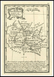
SOUTH WEST Part of Germany, Kupferstich aus dem Atlas MINIMUS, by
J. ...mehr SOUTH WEST Part of Germany, Kupferstich aus dem Atlas MINIMUS, by J. Gibson, London 1774
J. ...mehr SOUTH WEST Part of Germany, Kupferstich aus dem Atlas MINIMUS, by J. Gibson, London 1774
45.00 EUR
(ca. 51 USD) 21.04.2025 12:00 CEST
(ca. 51 USD) 21.04.2025 12:00 CEST
Nordphila e.K.
Los 3919

Mi
(7x10)
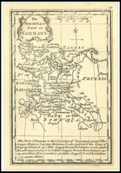
The NORTH WEST Part of Germany, Kupferstich aus dem Atlas MINIMUS,
by ...mehr The NORTH WEST Part of Germany, Kupferstich aus dem Atlas MINIMUS, by J. Gibson, London 1774
by ...mehr The NORTH WEST Part of Germany, Kupferstich aus dem Atlas MINIMUS, by J. Gibson, London 1774
45.00 EUR
(ca. 51 USD) 21.04.2025 12:00 CEST
(ca. 51 USD) 21.04.2025 12:00 CEST
Nordphila e.K.
Los 3922
Mi
(7x10)
NORTH EAST Part of Germany, Kupferstich aus dem Atlas MINIMUS, by
J. ...mehr NORTH EAST Part of Germany, Kupferstich aus dem Atlas MINIMUS, by J. Gibson, London 1774
J. ...mehr NORTH EAST Part of Germany, Kupferstich aus dem Atlas MINIMUS, by J. Gibson, London 1774
45.00 EUR
(ca. 51 USD) 21.04.2025 12:00 CEST
(ca. 51 USD) 21.04.2025 12:00 CEST
Nordphila e.K.
Los 3920
Mi
(7x10)
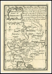
SOUTH EAST Part of Germany, Kupferstich aus dem Atlas MINIMUS, by
J. ...mehr SOUTH EAST Part of Germany, Kupferstich aus dem Atlas MINIMUS, by J. Gibson, London 1774
J. ...mehr SOUTH EAST Part of Germany, Kupferstich aus dem Atlas MINIMUS, by J. Gibson, London 1774
45.00 EUR
(ca. 51 USD) 21.04.2025 12:00 CEST
(ca. 51 USD) 21.04.2025 12:00 CEST
Nordphila e.K.
Los 3910
Mi
(40x53)
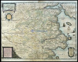
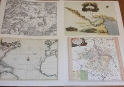
die Gegend zwischen Hadersleben und Kolding, "Landtcarte ...mehr
die Gegend zwischen Hadersleben und Kolding, "Landtcarte vom
Ostertheile des Ambtes Hatersleben, genandt Baringsyssell",
kolorierter Kupferstich aus Danckwerth von 1652, aufgezogen, links
knapprandig
210.00 EUR
(ca. 238 USD) 26.05.2025 14:00 CEST
(ca. 238 USD) 26.05.2025 14:00 CEST
Nordphila e.K.
Los 3915
Mi
(46x57)
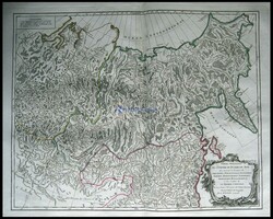
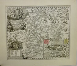
der östliche Teil von Rußland, "Partie Orientale de L`Empire ...mehr
der östliche Teil von Rußland, "Partie Orientale de L`Empire de
Russie
100.00 EUR
(ca. 113 USD) 26.05.2025 14:00 CEST
(ca. 113 USD) 26.05.2025 14:00 CEST
Nordphila e.K.
Los 3927
Mi
(50x60)
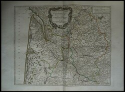
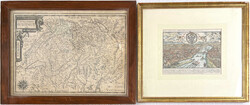
die Provinzen "Le Bourdelois, Le Perigord, L`Agenois, Le ...mehr
die Provinzen "Le Bourdelois, Le Perigord, L`Agenois, Le Bazadois",
altkolorierter Kupferstich von Gilles Robert de Vaudondy, Atlas
Univers. Paris 1757/8
170.00 EUR
(ca. 193 USD) 21.04.2025 12:00 CEST
(ca. 193 USD) 21.04.2025 12:00 CEST
Teutoburger Münzauktion GmbH
Los 5573
37 Stück: 20 kolorierte Kupferstich-Landkarten 1750 ...mehr
37 Stück: 20 kolorierte Kupferstich-Landkarten 1750 von
Jacques-Nicolas Bellin (1703-1772). Teils Dubletten. 13 kolorierte
Kupferstich-Ansichten 1685 von Alain Manesson Mallet (1630-1706),
u.a. von Medina, Kupferstich um 1650 von Matthäus Merian (Ansicht
Frankfurt/Oder), Blatt aus der Cosmographia von Sebastian Münster
1580 mit koloriertem Holzschnitt, Karte Kroatiens. Faksimile
(Offset) nach der Karte 1682 von Johannes Janssonius (1588 - 1664)
Bremen und Verden (gerahmt mit Passepartout hinter Glas, Gesamtmaße
64 X 70,5 cm). Deutschlandkarte von Snellius 1745 (gerahmt hinter
Glas). teils stockfleckig, KEIN VERSAND/NO SHIPPING POSSIBLE
Teutoburger Münzauktion GmbH
Los 5574
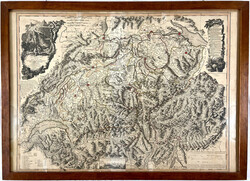
Kolorierte Kupferstich-Landkarte 1792 von William Faden ...mehr
Kolorierte Kupferstich-Landkarte 1792 von William Faden (1749-1836,
London). Nouvelle Carte de la Suisse dans laquelle sont exactement
distingues Les Treize Cantons. 97 X 70,5 cm. Gerahmt hinter Glas.
KEIN VERSAND/NO SHIPPING POSSIBLE
Ava Auctions
Los 2141
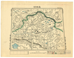
1937 a map of Tannu Uriankhai, with the seal of library of ...mehr
1937 a map of Tannu Uriankhai, with the seal of library of Minzu
University of China. (size: 39x 31).
1937年唐努烏梁海地圖一份,鈐中央民族學院圖書館戳記。(39 x 31厘米)
1937年唐努烏梁海地圖一份,鈐中央民族學院圖書館戳記。(39 x 31厘米)
Abacus Auctions
Los 3346
4 weitere Abbildungen
Collection including UK mainly Ordnance Survey maps (47); ...mehr
Collection including UK mainly Ordnance Survey maps (47); Ireland
(2); Switzerland (2); South Australia (7); National Geographic
(25); 'Newnes Motorist Touring Maps & Gazetteer' (UK); plus compass
& bag of marbles, mainly Fair/Fine.
(86)
(86)
75.00 AUD
(ca. 42 EUR, ca. 48 USD) 28.03.2025 09:30 AEDT
(ca. 42 EUR, ca. 48 USD) 28.03.2025 09:30 AEDT
Auktionshaus Kempf
Los 563
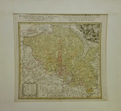
Landkarte Bautzener Kreis, "Geographische Verzeichnung ...mehr
Landkarte Bautzener Kreis, "Geographische Verzeichnung des
Budissinischen Creises in dem Marggrafenthum Ober Lausitz ..."
Homann Erben, Nürnberg 1746, Grenzkolorierter Kupferstich, u. PP
70cm x 66cm
20.00 EUR
(ca. 23 USD) 02.05.2025 18:00 CEST
(ca. 23 USD) 02.05.2025 18:00 CEST
Auktionshaus Kempf
Los 564
Kupferstich, historische Karte von Thüringen, ''Ejusdem ...mehr
Kupferstich, historische Karte von Thüringen, ''Ejusdem Principatus
Saxo-Hildburghusiam Novam et exactam tabulam Submississime...'',
colorierte Kupferstichkarte bei Homann in Nürnberg um 1720, mit
großer figürlicher Titelkartusche mit Dedikation oben links,
Wappenkartusche mit Erklärungen unten links sowie einem Plan von
Hildburghausen, Karte zeigt das Fürstentum Hildburghausen mit den
Ämtern Eisfeld, Schalkau, Sonnenfeld, Heldburg und Königsberg
zwischen Schleusingen, Steinach, Hassfurt und Mellrichstadt, u. PP
69cm x 60cm
20.00 EUR
(ca. 23 USD) 02.05.2025 18:00 CEST
(ca. 23 USD) 02.05.2025 18:00 CEST
Ava Auctions
Los 2081
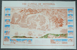
1985 A panoramic view map of Urga in early 20th century, ...mehr
1985 A panoramic view map of Urga in early 20th century, headlined
"THE CAPITAL OF MONGOLIA (Beginning of the XX century)". Size 35 x
100 cm. The painting depicts the Mongolian Buddhist monastery of
the Jibzundamba reincarnate rulers. When the monastery settled in
1855, it soon developed into a thriving city with palaces and
international commercial districts. The map was a part of a larger
Mongolian nation-building project, and a royal commission to
promote the Khalkha Mongolian monastery as a pilgrimage site of
Mongolia.
1985年印制,二十世紀初庫倫鳥瞰地圖一幅,尺寸35 x 100厘米。圖中可見甘丹寺。烏蘭巴托的城市發展與甘丹寺密不可分。此地圖更是蒙古國身份認同的一部分。
1985年印制,二十世紀初庫倫鳥瞰地圖一幅,尺寸35 x 100厘米。圖中可見甘丹寺。烏蘭巴托的城市發展與甘丹寺密不可分。此地圖更是蒙古國身份認同的一部分。
Nordphila e.K.
Los 3893
1 weitere Abbildung
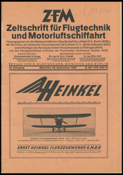
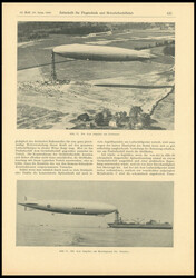
1928, Zeitschrift für Flugtechnik und Motorluftschiffahrt ...mehr
1928, Zeitschrift für Flugtechnik und Motorluftschiffahrt 19.
Jahrgang, Heft 18, S. 401-440, im Verlag von Oldenburg, München und
Berlin, erschienen, belesen
40.00 EUR
(ca. 45 USD) 21.04.2025 12:00 CEST
(ca. 45 USD) 21.04.2025 12:00 CEST
Hodam Auktion
Los 3477
alte Landkarten: 24 farbige Karten, alles Nachdrucke der DDR aus
1987 ...mehr alte Landkarten: 24 farbige Karten, alles Nachdrucke der DDR aus 1987 auf "Büttenpapier", ehemals teuer gekauft!
1987 ...mehr alte Landkarten: 24 farbige Karten, alles Nachdrucke der DDR aus 1987 auf "Büttenpapier", ehemals teuer gekauft!
40.00 EUR
(ca. 45 USD) 01.06.2025 12:00 CEST
(ca. 45 USD) 01.06.2025 12:00 CEST
David Feldman S. A. Genf
Los 80707

1800s India map by John Tallis & Co. London and NY. The map was
drawn ...mehr 1800s India map by John Tallis & Co. London and NY. The map was drawn and engraved by J. Rapkin and printed on thick wove paper. An rare, exhibition showpiece. Ex. Dan Walker
drawn ...mehr 1800s India map by John Tallis & Co. London and NY. The map was drawn and engraved by J. Rapkin and printed on thick wove paper. An rare, exhibition showpiece. Ex. Dan Walker
100.00 GBP
(ca. 118 EUR, ca. 133 USD) 30.05.2025 12:00 BST
(ca. 118 EUR, ca. 133 USD) 30.05.2025 12:00 BST
David Feldman S. A. Genf
Los 80708
1800s Indian Ocean map showing the steam packet routes ...mehr
1800s Indian Ocean map showing the steam packet routes marked.
Engraved by Edward Walker on thick wove paper. Water stained and
toned but a rare, exhibition showpiece or research material. Ex.
Dan Walker
100.00 GBP
(ca. 118 EUR, ca. 133 USD) 30.05.2025 12:00 BST
(ca. 118 EUR, ca. 133 USD) 30.05.2025 12:00 BST
Teutoburger Münzauktion GmbH
Los 5572
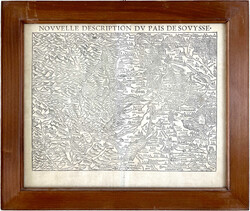
3 Stück: Kupferstich-Landkarte 1653 von Pierre-Jean Mariett ...mehr
3 Stück: Kupferstich-Landkarte 1653 von Pierre-Jean Mariett und
Nicolas Tassin "Carte generale des treze cantons de Suisse",
kolorierter Holzschnitt Ansicht von Frankfurt a.M. und
Kupferstich-Landkarte NOVVELLE DESCRIPTION DV PAIS DE SOVYSSE aus
Sebastian Münsters Cosmographia. Jeweils gerahmt hinter Glas. KEIN
VERSAND/NO SHIPPING POSSIBLE
Teutoburger Münzauktion GmbH
Los 5570
1 weitere Abbildung
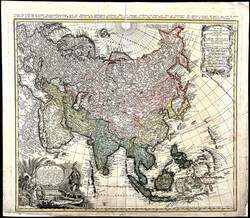
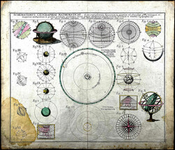
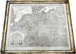
3 kolorierte Kupferstiche: Landkarte IMPERII RUSSICI 1739 von
Johann ...mehr 3 kolorierte Kupferstiche: Landkarte IMPERII RUSSICI 1739 von Johann Matthias Hasius, Landkarte ASIA 1744 von Jihann Mathias Hasius, Kupferstich SCHEMATISMUVS GEOGRAPHIAE MATHEMATICAE 1753 von Homann. III, einmal fleckig
Johann ...mehr 3 kolorierte Kupferstiche: Landkarte IMPERII RUSSICI 1739 von Johann Matthias Hasius, Landkarte ASIA 1744 von Jihann Mathias Hasius, Kupferstich SCHEMATISMUVS GEOGRAPHIAE MATHEMATICAE 1753 von Homann. III, einmal fleckig
Teutoburger Münzauktion GmbH
Los 5571
17 diverse alte Landkarten. U.a. Bielefeld Stadtplan, ...mehr
17 diverse alte Landkarten. U.a. Bielefeld Stadtplan, "Der
Nordseeraum und Westeuropa mit Westwall und Maginot-Linie", viele
Wanderkarten, usw. unterschiedlich erhalten
Bill Barrell Ltd
Los 72199
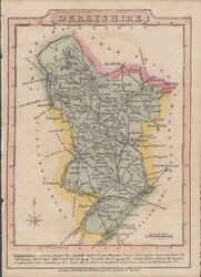
MAP/DERBYSHIRE. A very fine map by J.Wallis produced for his ...mehr
MAP/DERBYSHIRE. A very fine map by J.Wallis produced for his 1814
Travellers Companion pocket edition (102x140mm). Some pastel
colouring. (Ref 72199).
Bill Barrell Ltd
Los 74470
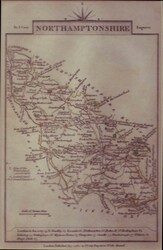
1812 NORTHAMPTONSHIRE MAP. A fine map (108 x 164) engraved ...mehr
1812 NORTHAMPTONSHIRE MAP. A fine map (108 x 164) engraved and
published by John Cary in 1812. (Ref 74470).
Bill Barrell Ltd
Los 131862
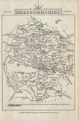
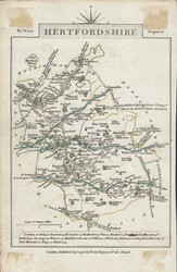
1792 MAP OF HEREFORDSHIRE AND ON REVERSE HERTFORDSHIRE BY CARY.
Fine ...mehr 1792 MAP OF HEREFORDSHIRE AND ON REVERSE HERTFORDSHIRE BY CARY. Fine maps of Herefordshire and Hertfordshire, 1792 printing by Cary in black on white wove paper (162 x 104). (Ref 131862).
Fine ...mehr 1792 MAP OF HEREFORDSHIRE AND ON REVERSE HERTFORDSHIRE BY CARY. Fine maps of Herefordshire and Hertfordshire, 1792 printing by Cary in black on white wove paper (162 x 104). (Ref 131862).
Bill Barrell Ltd
Los 112580
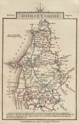
1819 MAP OF DORSET BY CARY. A fine map of Dorsetshire (181x108mm)
by ...mehr 1819 MAP OF DORSET BY CARY. A fine map of Dorsetshire (181x108mm) by J. Cary published 1819. (Ref 112580).
by ...mehr 1819 MAP OF DORSET BY CARY. A fine map of Dorsetshire (181x108mm) by J. Cary published 1819. (Ref 112580).
Aktuelle Zeit: 02.05.2025 - 17:46 Uhr MET
